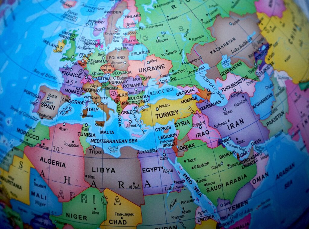
superimposed boundaries
A superimposed boundary is a boundary that was established without consideration for the pre-existing inhabitants of the area it encompasses. Superimposed boundaries have left an indelible mark on the world map, shaping the destinies of nations. And often fueling conflicts and tensions. External forces impose these political boundaries without considering the cultural and ethnic realities of the affected regions. These have had far-reaching consequences. This article delves into the implications of superimposed boundaries and provides a prominent example to illustrate their impact.
Implications of Superimposed Boundaries:
Disregard for Cultural and Ethnic Realities:
Superimposed boundaries often ignore the complex tapestry of cultures, ethnicities, and historical affiliations that exist within a region. They impose a rigid demarcation that may divide communities, disrupt traditional ways of life, and stifle social cohesion.
Ethnopolitical Tensions:
When different ethnic groups find themselves divided by arbitrary borders, tensions can arise. Disputes over land, resources, and political representation become common, fueling conflicts that can last for generations. The lack of consideration for existing ethnic fault lines can lead to long-standing animosity and instability.
Economic Fragmentation:
Superimposed boundaries can impede economic integration and development. Disruptions in trade routes, division of natural resources, and hindrances to cross-border economic cooperation may occur. This fragmentation can limit the potential for economic growth and exacerbate disparities within and between nations.
Political Instability:
Imposed boundaries create artificial nation-states with diverse populations. These nations often struggle to establish stable political systems. Ethnic rivalries, grievances, and a lack of shared history hinder the formation of inclusive governance structures. This leads to political instability and, in some cases, state failure.
Read about the best BOOKS ABOUT EDUCATION REFORM
20 Examples Of Superimposed Boundaries
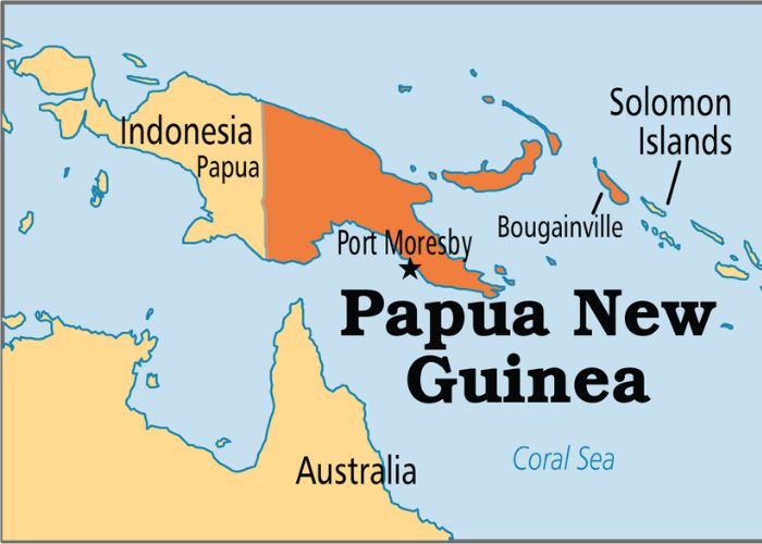
The Australia-Papua New Guinea Border:
The Australia-Papua New Guinea border stretches for approximately 820 kilometers. In 1978, the Papua New Guinea-Australia Maritime Boundaries Treaty officially established the border between the Australian territories of Queensland and the Torres Strait Islands and the sovereign state of Papua New Guinea. This treaty marked the division and demarcation of the maritime boundaries between these regions.
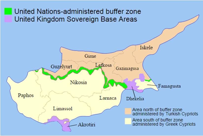
The Cyprus Green Line:
The United Nations controls the Cyprus Green Line, which separates the island of Cyprus into the Greek Cypriot-controlled south and the Turkish Cypriot-controlled north. After inter-communal conflicts, the United Nations established the Cyprus Green Line in 1964, and it has served as a demarcation line ever since.
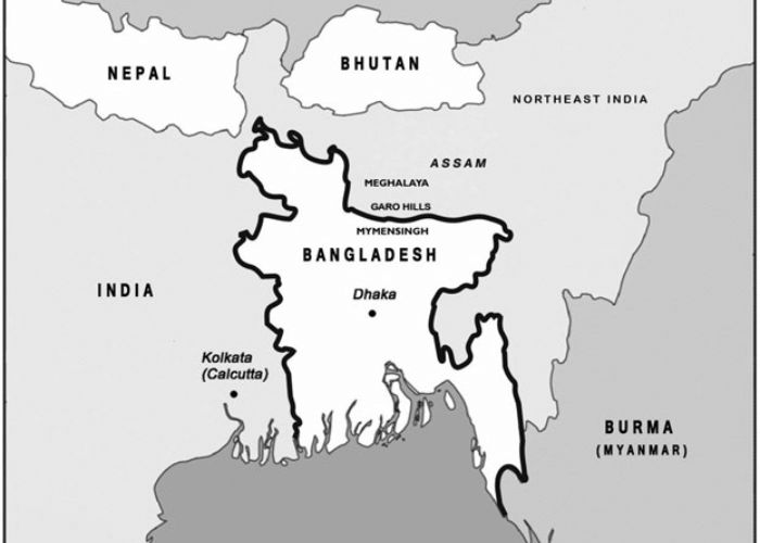
The India-Bangladesh Border:
During the partition of British India in 1947, the partition commission established the India-Bangladesh border, known as the Radcliffe Line. It spans approximately 4,096 kilometers, making it one of the longest land borders in the world, and separates the countries of India and Bangladesh.
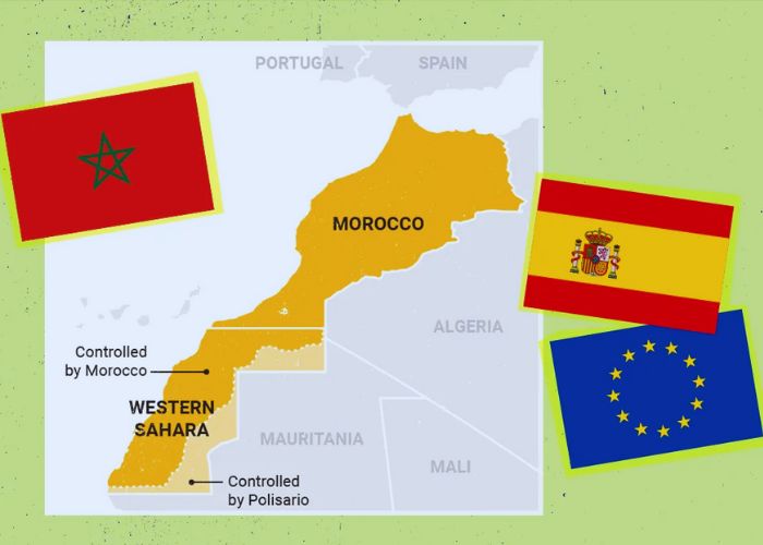
The Morocco-Western Sahara Border:
The border between Morocco and Western Sahara is a disputed boundary resulting from the ongoing conflict over the sovereignty of Western Sahara. Morocco considers Western Sahara as part of its territory, while the Polisario Front seeks independence for the region. The border remains a contentious issue.
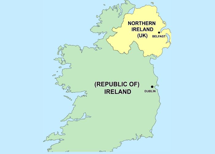
The Ireland-UK Border (excluding Northern Ireland):
The Ireland-UK border refers to the land boundary between the Republic of Ireland (an independent country) and Northern Ireland (part of the United Kingdom). It became a significant point of focus during the negotiations surrounding the United Kingdom’s exit from the European Union, commonly referred to as Brexit.

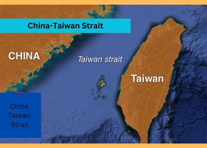
The China-Taiwan Strait:
The Taiwan Strait is a body of water that separates the island of Taiwan from mainland China. It represents the geopolitical divide between the People’s Republic of China, which claims Taiwan as part of its territory, and the Republic of China (Taiwan), which operates as a separate political entity.
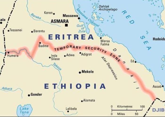
The Ethiopia-Eritrea Border:
The Ethiopia-Eritrea border marks the boundary between the countries of Ethiopia and Eritrea. It was established following Eritrea’s independence from Ethiopia in 1993. However, border disputes and conflicts arose, leading to the Eritrean-Ethiopian War (1998-2000). Efforts to demarcate the border have been ongoing since then.
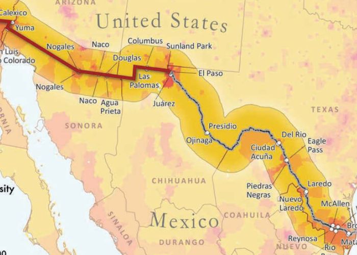
The US-Mexico Border:
The US-Mexico border stretches approximately 3,145 kilometers, marking the boundary between the United States and Mexico. Various treaties and agreements, including the Treaty of Guadalupe Hidalgo in 1848 and the Gadsden Purchase in 1853, primarily established it.
The Northern Ireland Border:
The Northern Ireland border refers to the boundary between Northern Ireland (part of the United Kingdom) and the Republic of Ireland. It became a significant point of concern during the ethno-nationalist conflict known as “The Troubles” that plagued Northern Ireland from the late 1960s to the late 1990s.
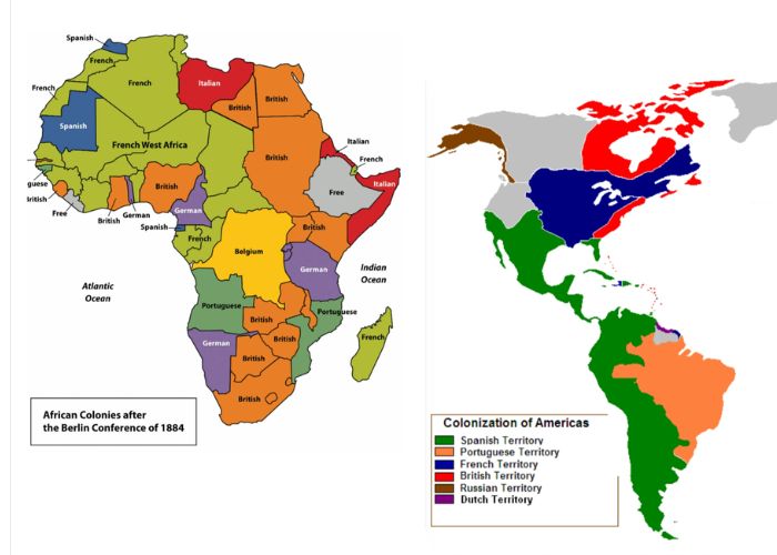
The Creation of African Colonies:
The creation of African colonies refers to the division of the African continent among European powers during the colonial era, mainly from the late 19th century to the mid-20th century. The drawing of boundaries by colonial powers disregarded existing cultural, ethnic, and geographic realities, leading to numerous challenges and conflicts in post-colonial Africa.
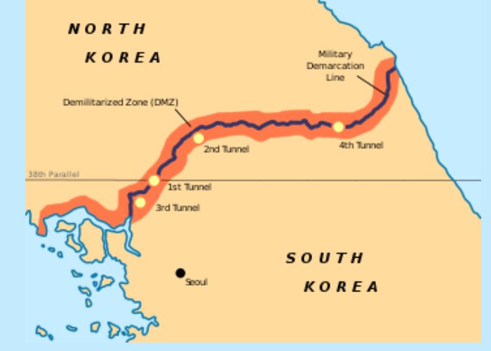
The Korean Demilitarized Zone:
The Korean Demilitarized Zone (DMZ) is a 4-kilometer-wide buffer zone that separates North Korea and South Korea. It was established in 1953 as part of the armistice agreement that ended the Korean War. The DMZ serves as a heavily fortified and strictly regulated area, maintaining a delicate peace between the two countries.
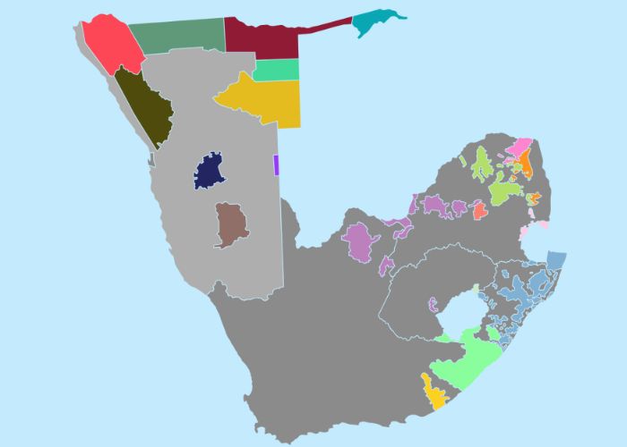
The Bantustans in South Africa:
During the apartheid era, South Africa established the Bantustans as territories. The authorities designated these areas for specific ethnic groups, forcibly removing marginalized populations from more developed regions. The creation of Bantustans aimed to maintain racial segregation and solidify white minority rule.
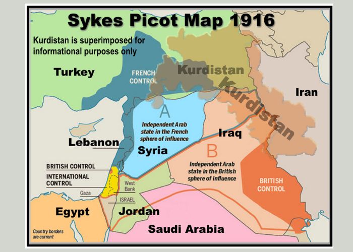
The Sykes-Picot Agreement Dividing the Middle East:
The Sykes-Picot Agreement was a secret agreement between the United Kingdom and France in 1916 during World War I. It aimed to divide the Middle East region into spheres of influence for the two colonial powers. The agreement laid the groundwork for the subsequent creation of nation-states in the region and has had lasting consequences.
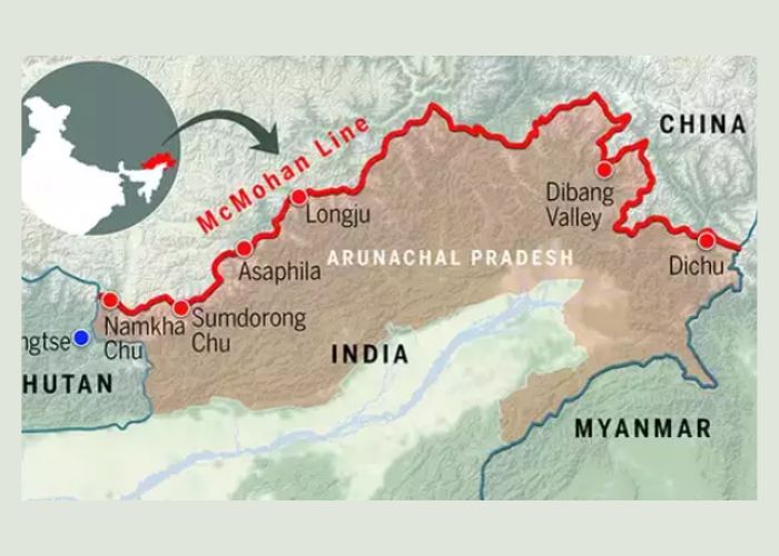
The McMahon Line Separating India and Tibet/China:
British colonial official Sir Henry McMahon proposed the McMahon Line in 1914, delineating the border between Tibet/China and India’s northeastern region. It has been a subject of dispute between India and China, contributing to the Sino-Indian border conflict.
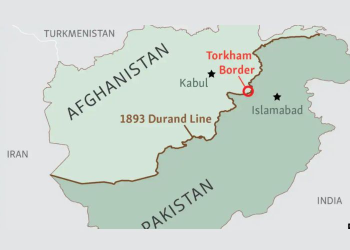
The Durand Line Separating Afghanistan and Pakistan:
British colonial official Sir Mortimer Durand drew the Durand Line in 1893, establishing it as a boundary line that separates present-day Pakistan from Afghanistan. It has been a contentious border, with Afghanistan refusing to recognize it, leading to ongoing tensions between the two countries.
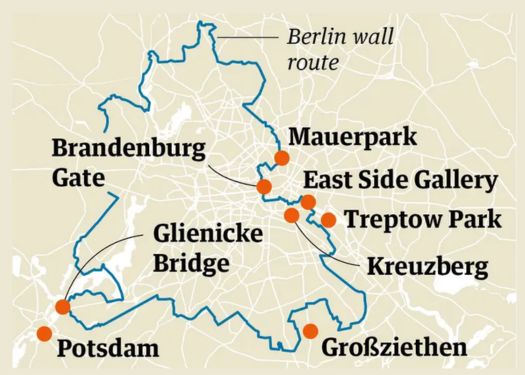
The Berlin Wall:
East Germany erected the Berlin Wall in 1961 as a physical barrier to separate East Berlin, which was under communist control, from West Berlin, a democratic enclave within East Germany. It became a symbol of the Cold War division between the Eastern Bloc and the Western world until its fall in 1989.
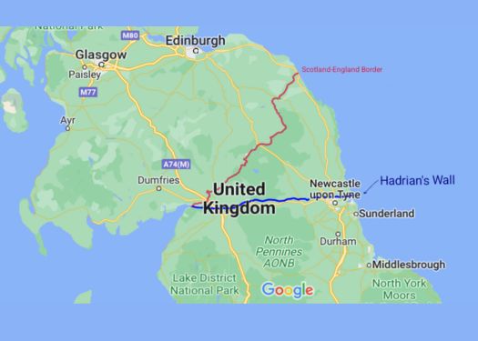
Hadrian’s Wall:
Hadrian’s Wall is a Roman fortification built in AD 122 under the rule of Emperor Hadrian. It stretches across Northern England and served as a defensive barrier marking the northernmost limit of the Roman Empire.
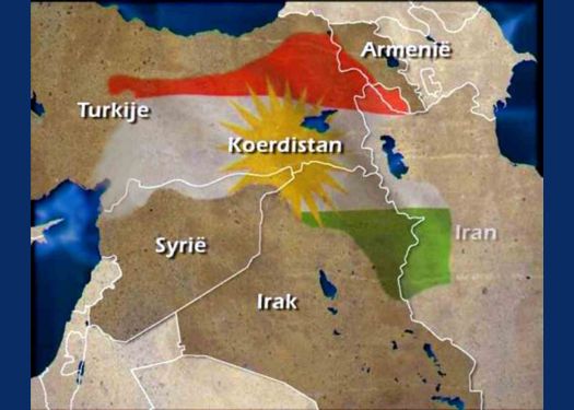
The Division of Kurdistan:
The division of Kurdistan occurs because several countries, including Iraq, Turkey, Syria, and Iran, divide the Kurdish population, preventing the establishment of a unified Kurdish state. The boundaries drawn by colonial powers after World War I failed to recognize Kurdish aspirations for self-determination.
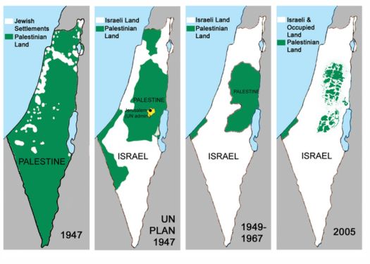
The Green Line Separating Israel and the Palestinian Territories:
After the Arab-Israeli War, the Green Line was established as an armistice line in 1949. It serves as the de facto border between Israel and the Palestinian territories of the West Bank, Gaza Strip, and East Jerusalem.
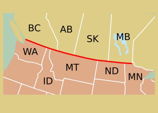
The 49th Parallel US-Canada Border:
The 49th Parallel is the boundary line between the United States and Canada, stretching from the Pacific Ocean to the Lake of the Woods in the east. The Treaty of 1818 established it, and it remains the longest undefended border in the world.
FAQs
Q1: What are superimposed boundaries?
A1: Read Here.
Q2: What are some examples of superimposed boundaries?
A2: Check Here.
Q3: What are the implications of superimposed boundaries?
A3: Click Here to Read.
Q4: How do superimposed boundaries affect communities?
A4: Superimposed boundaries can lead to the division of communities, disruption of cultural and social ties, and marginalization of certain groups. They can create identity crises, erode social cohesion, and perpetuate inequalities among different ethnic or cultural groups.
Q5: Can superimposed boundaries be resolved?
A5: Resolving the issues associated with superimposed boundaries often requires diplomatic negotiations, peace agreements, and inclusive governance structures. It may involve efforts to address historical grievances, promote cross-border cooperation, and recognize the aspirations and identities of the affected populations.
Q6: How can the negative effects of superimposed boundaries be mitigated?
A6: Mitigating the negative effects of superimposed boundaries requires efforts to promote inclusivity, reconciliation, and dialogue among affected communities. It involves recognizing and respecting the cultural and ethnic diversity of the regions, promoting cross-border cooperation, and addressing historical injustices.
Q7: Are superimposed boundaries a thing of the past?
A7: While many superimposed boundaries were established during the colonial era, their effects are still felt today. Some conflicts and tensions persist, and efforts to redraw or redefine boundaries are ongoing in certain regions, reflecting the lasting impact of these boundaries on the world map.